
Gracias por apoyar a este sitio ❤️
Haz una donación
Haz una donación
Mapa topográfico Lauf
Haga clic en el mapa para ver la altitud.
Gracias por apoyar a este sitio ❤️
Haz una donación
Haz una donación
Lauf
The geographical feature that provides the name to Lauf is the Laufbach stream. This body of water originates from the northwestern side of the Hornisgrinde, subsequently flowing past Glashütte and eventually reaching Lauf. Its rapid descent forms a distinctive feature of the local topography.
Gracias por apoyar a este sitio ❤️
Haz una donación
Haz una donación
Acerca de este mapa
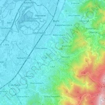
Nombre: Mapa topográfico Lauf, altitud, relieve.
Altitud media: 297 m
Altitud mínima: 122 m
Altitud máxima: 1,136 m
Gracias por apoyar a este sitio ❤️
Haz una donación
Haz una donación
Otros mapas topográficos
Haga clic en un mapa para ver su topografía, su altitud y su relieve.
Gracias por apoyar a este sitio ❤️
Haz una donación
Haz una donación
Gracias por apoyar a este sitio ❤️
Haz una donación
Haz una donación