
Mapa topográfico Charles Town
Mapa interactivo
Haga clic en el mapa para ver la altitud.
Acerca de este mapa
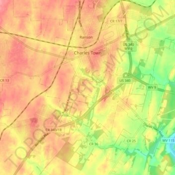
Nombre: Mapa topográfico Charles Town, altitud, relieve.
Lugar: Charles Town, Jefferson County, West Virginia, United States (39.25539 -77.90614 39.29551 -77.81743)
Altitud media: 150 m
Altitud mínima: 99 m
Altitud máxima: 182 m
Due to its low elevation for West Virginia, Charles Town is on the northern extent of the Humid Subtropical climate zone, having cool to mildly cold winters and hot and humid summers. Precipitation is evenly distributed throughout the year, providing lush, abundant plant growth.
Otros mapas topográficos
Haga clic en un mapa para ver su topografía, su altitud y su relieve.
Harpers Ferry
United States > West Virginia > Jefferson County
Harpers Ferry, Jefferson County, West Virginia, United States
Altitud media: 174 m
Shepherdstown
United States > West Virginia > Jefferson County
Shepherdstown, Jefferson County, West Virginia, 25443, United States
Altitud media: 126 m
Kearneysville
United States > West Virginia > Jefferson County > Kearneysville
Kearneysville, Jefferson County, West Virginia, 25430-9047, United States
Altitud media: 162 m
Harpers Ferry National Historical Park
United States > West Virginia > Jefferson County > Bolivar
Harpers Ferry National Historical Park, Bolivar, Jefferson County, West Virginia, United States
Altitud media: 161 m
Halltown
United States > West Virginia > Jefferson County > Halltown
Halltown, Jefferson County, West Virginia, 25423, United States
Altitud media: 133 m
Ranson
United States > West Virginia > Jefferson County
Ranson, Jefferson County, West Virginia, 25438, United States
Altitud media: 161 m