
Gracias por apoyar a este sitio ❤️
Haz una donación
Haz una donación
Mapa topográfico Paruthumpara
Haga clic en el mapa para ver la altitud.
Gracias por apoyar a este sitio ❤️
Haz una donación
Haz una donación
Acerca de este mapa
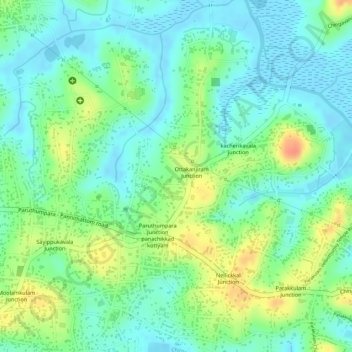
Nombre: Mapa topográfico Paruthumpara, altitud, relieve.
Lugar: Paruthumpara, Kottayam, Kerala, India (9.52765 76.53839 9.54066 76.54552)
Altitud media: 19 m
Altitud mínima: -5 m
Altitud máxima: 50 m
Gracias por apoyar a este sitio ❤️
Haz una donación
Haz una donación
Otros mapas topográficos
Haga clic en un mapa para ver su topografía, su altitud y su relieve.
Kottayam
Kottayam has an average elevation of 3 metres (9.8 ft) above sea level. and is situated in the basin of the Meenachil River and in the basin of the Vembanad backwaters, which are formed from several streams in the Western Ghats in Idukki district. According to the division of places in Kerala based on…
Altitud media: 19 m
Gracias por apoyar a este sitio ❤️
Haz una donación
Haz una donación
Gracias por apoyar a este sitio ❤️
Haz una donación
Haz una donación