
Haz una donación
Mapa topográfico Sirkazhi
Haga clic en el mapa para ver la altitud.
Haz una donación
Sirkazhi
Sirkazhi is located at 11°14′N 79°44′E / 11.23°N 79.73°E / 11.23; 79.73, on the eastern flank of the Kumbakonam-Shiyali ridge, which runs along the Kollidam River. Sirkazhi has an average elevation of 5.18 m (17.0 ft) above sea level and is located at 13 km (8.1 mi) west of Bay of Bengal. It is located 95 km (59 mi) north-east of Thanjavur, 24 km (15 mi) north of Mayiladuthurai and 20 kilometres (12 mi) south of Chidambaram.
Haz una donación
Acerca de este mapa
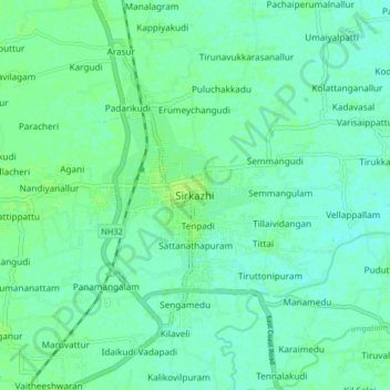
Nombre: Mapa topográfico Sirkazhi, altitud, relieve.
Altitud media: 5 m
Altitud mínima: 0 m
Altitud máxima: 10 m
Haz una donación
Otros mapas topográficos
Haga clic en un mapa para ver su topografía, su altitud y su relieve.
Cauvery
India > Tamil Nadu > Sirkali > Alangadu
The Kaveri (also known as Cauvery, the anglicised name) is one of the major Indian rivers flowing through the states of Karnataka and Tamil Nadu. The Kaveri River rises at Talakaveri in the Brahmagiri range in the Western Ghats, Kodagu district of the state of Karnataka, at an elevation of 1,341 m above mean…
Altitud media: 7 m