
Haz una donación
Mapa topográfico Peguera
Haga clic en el mapa para ver la altitud.
Haz una donación
Acerca de este mapa
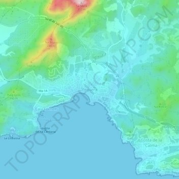
Nombre: Mapa topográfico Peguera, altitud, relieve.
Altitud media: 51 m
Altitud mínima: 0 m
Altitud máxima: 344 m
Haz una donación
Otros mapas topográficos
Haga clic en un mapa para ver su topografía, su altitud y su relieve.
Serra de Tramuntana
Spain > Balearic Islands > Serra de Tramuntana
The climate in the Tramuntana Range is significantly wetter than the rest of the island, recording as much as 1507 mm (59.3 inches) of precipitation per year, in comparison with some other parts of the island where annual rainfall is less than 400mm (15 inch). It is also cooler due to the altitude, and a few…
Altitud media: 175 m
Haz una donación
Haz una donación
Calvià
Spain > Balearic Islands > Serra de Tramuntana
Calvià first appears in history as a village 2,000 years BCE, although the area was first populated in the Neolithic Era. Later, sailors coming from the east stopped in the Balearics on their way to the Iberian Peninsula, where they sought metals. They came from Italy, from other Mediterranean islands, and…
Altitud media: 134 m
Haz una donación
Serra de Tramuntana
Spain > Balearic Islands > Serra de Tramuntana
The climate in the Tramuntana Range is significantly wetter than the rest of the island, recording as much as 1507 mm (59.3 inches) of precipitation per year, in comparison with some other parts of the island where annual rainfall is less than 400mm (15 inch). It is also cooler due to the altitude, and a few…
Altitud media: 175 m
Haz una donación
Haz una donación