
Haz una donación
Mapa topográfico Whitworth
Haga clic en el mapa para ver la altitud.
Haz una donación
Acerca de este mapa
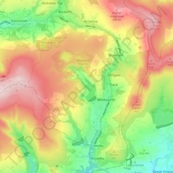
Nombre: Mapa topográfico Whitworth, altitud, relieve.
Altitud media: 317 m
Altitud mínima: 159 m
Altitud máxima: 477 m
Haz una donación
Otros mapas topográficos
Haga clic en un mapa para ver su topografía, su altitud y su relieve.
Bacup
United Kingdom > England > Lancashire > Borough of Rossendale
The geology and topography of the village lent itself to urbanisation and domestic industries; primitive weavers' cottages, coal pits and stone quarries were propelled by Bacup's natural supply of water power in the Early Modern period. The adoption of the factory system, which developed into the Industrial…
Altitud media: 337 m
Haslingden Grane
United Kingdom > England > Lancashire > Borough of Rossendale > Haslingden
Altitud media: 287 m
Haz una donación
Irwell Springs
United Kingdom > England > Lancashire > Borough of Rossendale > Weir
Altitud media: 365 m
Haz una donación
Clowbridge
United Kingdom > England > Lancashire > Borough of Rossendale > Habergham Eaves
Altitud media: 319 m
Whitewell Bottom
United Kingdom > England > Lancashire > Borough of Rossendale > Sagar Holme
Altitud media: 281 m
Haz una donación
Trough Gate
United Kingdom > England > Lancashire > Borough of Rossendale > Britannia
Altitud media: 341 m
Forest Holme
United Kingdom > England > Lancashire > Borough of Rossendale > Water
Altitud media: 318 m
Nun Hills
United Kingdom > England > Lancashire > Borough of Rossendale > Stacksteads
Altitud media: 316 m
Haz una donación
Cowm Reservoir
United Kingdom > England > Lancashire > Borough of Rossendale > Whitworth > Shawforth
Altitud media: 302 m
Rake Head
United Kingdom > England > Lancashire > Borough of Rossendale > Stacksteads
Altitud media: 315 m
Haz una donación