
Mapa topográfico Bellevue
Mapa interactivo
Haga clic en el mapa para ver la altitud.
Acerca de este mapa
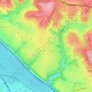
Nombre: Mapa topográfico Bellevue, altitud, relieve.
Lugar: Bellevue, Allegheny County, Pennsylvania, United States (40.48226 -80.06619 40.50823 -80.04454)
Altitud media: 285 m
Altitud mínima: 212 m
Altitud máxima: 365 m
According to the United States Census Bureau, the borough has a total area of 1.1 square miles (2.8 km2), of which 1.0 square mile (2.6 km2) is land and 0.1 square miles (0.26 km2), or 9.09%, is water. Its average elevation is 997 feet (304 m) above sea level.
Otros mapas topográficos
Haga clic en un mapa para ver su topografía, su altitud y su relieve.
Pleasant Hills
United States > Pennsylvania > Allegheny County
Pleasant Hills, Allegheny County, Pennsylvania, United States
Altitud media: 340 m
Warrendale
United States > Pennsylvania > Allegheny County
Warrendale, Marshall Township, Allegheny County, Pennsylvania, 15086, United States
Altitud media: 359 m
North Braddock
United States > Pennsylvania > Allegheny County
North Braddock, Allegheny County, Pennsylvania, 15104, United States
Altitud media: 282 m
Center
United States > Pennsylvania > Allegheny County > Plum
Center, Plum, Allegheny County, Pennsylvania, 15239, United States
Altitud media: 341 m
Clairton
United States > Pennsylvania > Allegheny County > Clairton
Clairton, Allegheny County, Pennsylvania, 15009:15025, United States
Altitud media: 281 m
Pittsburgh
United States > Pennsylvania > Allegheny County
Pittsburgh, Allegheny County, Pennsylvania, United States
Altitud media: 303 m
Elizabeth
United States > Pennsylvania > Allegheny County
Elizabeth, Allegheny County, Pennsylvania, United States
Altitud media: 273 m