
Mapa topográfico Monroe
Mapa interactivo
Haga clic en el mapa para ver la altitud.
Acerca de este mapa
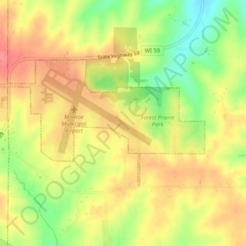
Nombre: Mapa topográfico Monroe, altitud, relieve.
Lugar: Monroe, Green County, Wisconsin, United States (42.60678 -89.60242 42.62073 -89.57297)
Altitud media: 312 m
Altitud mínima: 269 m
Altitud máxima: 343 m
Otros mapas topográficos
Haga clic en un mapa para ver su topografía, su altitud y su relieve.
Dayton
United States > Wisconsin > Green County
Dayton, Town of Exeter, Green County, Wisconsin, 53508, United States
Altitud media: 265 m
New Glarus
United States > Wisconsin > Green County > New Glarus
New Glarus, Green County, Wisconsin, 53574, United States
Altitud media: 285 m