
Haz una donación
Mapa topográfico Haripad
Haga clic en el mapa para ver la altitud.
Haz una donación
Haripad
Haripad is a town and municipality in Alappuzha District of Kerala State in India. Its coordinates are Latitude: 9°18′0″N and Longitude: 76°28′0″E, and lies at an elevation of 13 meters. It is bordered on the east by Pallippad, Karuvatta to the north, Kumarapuram and Mahadevikadu to the West, and on the south by Nangiarkulangara. Haripad is close to the Arabian Sea and connects Mavelikkara and Thrikkunnappuzha. Haripad Railway station is located in the heart of the town. Kayamkulam Junction is one of the major Railway stations which is at a distance of 14 kilometers. The nearest airport is at Kochi which is at a 3 h 5 min away (114.1 km) via NH66.
Haz una donación
Acerca de este mapa
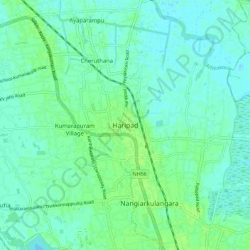
Nombre: Mapa topográfico Haripad, altitud, relieve.
Lugar: Haripad, Karthikappally, Alappuzha, Kerala, 690514, India (9.24449 76.41627 9.32449 76.49627)
Altitud media: 4 m
Altitud mínima: -1 m
Altitud máxima: 9 m
Haz una donación