
Mapa topográfico Green Valley
Mapa interactivo
Haga clic en el mapa para ver la altitud.
Acerca de este mapa
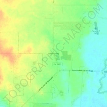
Nombre: Mapa topográfico Green Valley, altitud, relieve.
Lugar: Green Valley, Denton, Denton County, Texas, United States (33.29345 -97.08418 33.33345 -97.04418)
Altitud media: 180 m
Altitud mínima: 161 m
Altitud máxima: 202 m
Otros mapas topográficos
Haga clic en un mapa para ver su topografía, su altitud y su relieve.
Cooper Creek
United States > Texas > Denton County > Denton
Cooper Creek, Denton, Denton County, Texas, 76298, United States
Altitud media: 184 m
Mingo
United States > Texas > Denton County > Denton
Mingo, Denton, Denton County, Texas, 76298, United States
Altitud media: 172 m
North Pointe Park
United States > Texas > Denton County > Denton
North Pointe Park, Denton, Denton County, Texas, 76201, United States
Altitud media: 210 m
South Lakes Park
United States > Texas > Denton County > Denton
South Lakes Park, Denton, Denton County, Texas, 76205, United States
Altitud media: 201 m