
Haz una donación
Mapa topográfico Windsor
Haga clic en el mapa para ver la altitud.
Haz una donación
Acerca de este mapa
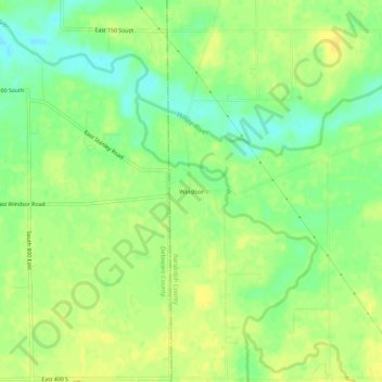
Nombre: Mapa topográfico Windsor, altitud, relieve.
Lugar: Windsor, Randolph County, Indiana, 47368, United States (40.13449 -85.23275 40.17449 -85.19275)
Altitud media: 312 m
Altitud mínima: 298 m
Altitud máxima: 321 m
Haz una donación
Otros mapas topográficos
Haga clic en un mapa para ver su topografía, su altitud y su relieve.
Parker City
United States > Indiana > Randolph County
According to the 2010 census, Parker City has a total area of 0.57 square miles (1.48 km2), all land. It is located at an elevation of 1025 feet.
Altitud media: 312 m
Haz una donación
Ridgeville
United States > Indiana > Randolph County
A post office called Ridgeville has been in operation since 1851. The town was named for its lofty elevation. Joab Ward, an old Settler to Ridgeville since 1819, originally laid out the village of Ridgeville, Randolph County, Indiana in 1854.
Altitud media: 306 m
Haz una donación