
Mapa topográfico Aberdeen
Mapa interactivo
Haga clic en el mapa para ver la altitud.
Acerca de este mapa
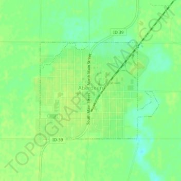
Nombre: Mapa topográfico Aberdeen, altitud, relieve.
Lugar: Aberdeen, Bingham County, Idaho, 83210, United States (42.93691 -112.84870 42.95138 -112.82435)
Altitud media: 1,341 m
Altitud mínima: 1,332 m
Altitud máxima: 1,345 m
Aberdeen is located at 42°56′36″N 112°50′22″W / 42.94333°N 112.83944°W / 42.94333; -112.83944 (42.943405, -112.839322), at an elevation of 4,403 feet (1,342 m) above sea level. According to the United States Census Bureau, the city has a total area of 1.03 square miles (2.67 km2), all of it land.
Otros mapas topográficos
Haga clic en un mapa para ver su topografía, su altitud y su relieve.
Blackfoot
United States > Idaho > Bingham County
Blackfoot, Bingham County, Idaho, 83221, United States
Altitud media: 1,371 m
Atomic City
United States > Idaho > Bingham County
Atomic City, Bingham County, Idaho, 83215, United States
Altitud media: 1,533 m
Fort Hall
United States > Idaho > Bingham County
Fort Hall, Bingham County, Idaho, 83203, United States
Altitud media: 1,356 m