
Mapa topográfico Tenkiller Ferry Lake
Mapa interactivo
Haga clic en el mapa para ver la altitud.
Acerca de este mapa
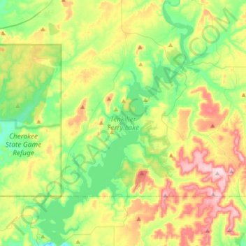
Nombre: Mapa topográfico Tenkiller Ferry Lake, altitud, relieve.
Altitud media: 258 m
Altitud mínima: 150 m
Altitud máxima: 448 m
The hydroelectric power station is remotely controlled from the control center at Fort Gibson Lake. Two generators, each rated for 17 megawatts, provide a total capacity of 34 megawatts (MWe). The facility can handle 40 MWe for a short period of time. However, the amount of power that can actually be generated depends heavily on the lake elevation at any given time.