
Haz una donación
Mapa topográfico Vaughan
Haga clic en el mapa para ver la altitud.
Haz una donación
Acerca de este mapa
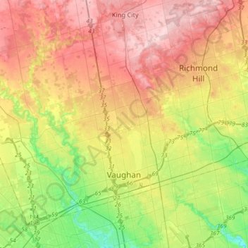
Nombre: Mapa topográfico Vaughan, altitud, relieve.
Lugar: Vaughan, York Region, Golden Horseshoe, Ontario, Canada (43.74984 -79.71069 43.92435 -79.42005)
Altitud media: 220 m
Altitud mínima: 118 m
Altitud máxima: 328 m
Haz una donación
Otros mapas topográficos
Haga clic en un mapa para ver su topografía, su altitud y su relieve.
Haz una donación
Keswick
Canada > Ontario > York Region
Keswick's geographical coordinates are 44.22°N, 79.45°W, and its elevation above sea level is 221m/762 ft. It has a geographical area of 16.25 km² according to Statistics Canada. It is bound on the north by Roches Point, the east by Woodbine Avenue, the south by East Gwillimbury (Ravenshoe Road) and the…
Altitud media: 228 m
Haz una donación
Haz una donación
Haz una donación
Haz una donación
Haz una donación
Haz una donación
Haz una donación
Whitchurch-Stouffville Community Park, Vandorf
Canada > Ontario > York Region > Whitchurch-Stouffville
Altitud media: 305 m
Haz una donación
East Holland River
Canada > Ontario > York Region > East Gwillimbury > Holland Landing
Altitud media: 223 m
Haz una donación
Haz una donación
Keswick
Canada > Ontario > York Region
Keswick's geographical coordinates are 44.22°N, 79.45°W, and its elevation above sea level is 221m/762 ft. It has a geographical area of 16.25 km² according to Statistics Canada. It is bound on the north by Roches Point, the east by Woodbine Avenue, the south by East Gwillimbury (Ravenshoe Road) and the…
Altitud media: 228 m
Haz una donación