
Mapa topográfico Decatur
Mapa interactivo
Haga clic en el mapa para ver la altitud.
Acerca de este mapa
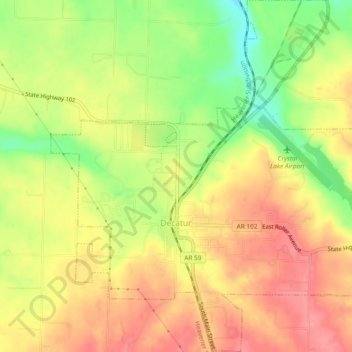
Nombre: Mapa topográfico Decatur, altitud, relieve.
Lugar: Decatur, Benton County, Arkansas, 72722, United States (36.32210 -94.47744 36.35985 -94.43075)
Altitud media: 379 m
Altitud mínima: 329 m
Altitud máxima: 414 m
Otros mapas topográficos
Haga clic en un mapa para ver su topografía, su altitud y su relieve.
Beaver Lake
United States > Arkansas > Benton County > Goshen
Beaver Lake, Goshen, Benton County, Arkansas, 72757, United States
Altitud media: 394 m
Coler Creek
United States > Arkansas > Benton County > Bentonville
Coler Creek, Bentonville, Benton County, Arkansas, 72716, United States
Altitud media: 371 m
Bentonville
United States > Arkansas > Benton County > Bentonville
Bentonville, Benton County, Arkansas, United States
Altitud media: 387 m