
Mapa topográfico Salmons Brook
Mapa interactivo
Haga clic en el mapa para ver la altitud.
Salmons Brook
It is not known at present whether Salmons Brook, and other west bank tributaries such as Pymmes Brook and Cuffley Brook, followed valleys which had been in existence before the ice sheet covered the land, or whether they fashioned a substantially different landscape after the ice retreated. But it is known that today's tributaries of the upper Lea, such as the Rivers Mimram and Stort, follow broadly the same lines as pre-glaciation valleys, so, by analogy, it is quite possible that elements at least of the pre-glaciation topography of the lower Lea basin are reflected in today's relief.
Acerca de este mapa
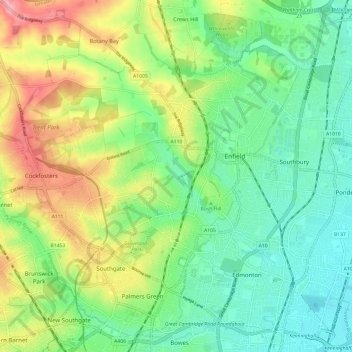
Nombre: Mapa topográfico Salmons Brook, altitud, relieve.
Altitud media: 42 m
Altitud mínima: 7 m
Altitud máxima: 104 m