
Mapa topográfico Cedar Grove
Mapa interactivo
Haga clic en el mapa para ver la altitud.
Acerca de este mapa
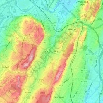
Nombre: Mapa topográfico Cedar Grove, altitud, relieve.
Lugar: Cedar Grove, Essex County, New Jersey, 07009, United States (40.81177 -74.26904 40.89177 -74.18904)
Altitud media: 108 m
Altitud mínima: 37 m
Altitud máxima: 211 m
The township is located between the First and Second Watchung Mountains. The center of the township is in a valley that is about 280 feet (85 m) above sea level; however, many sections of Cedar Grove are well above 400 feet (120 m), including the Park Ridge Estates, the abandoned Essex County Hospital Center, and the eastern, southeastern and southern sections of Cedar Grove. Cedar Grove's highest point is on hilltop, where elevations reach 600 feet (180 m) and above. Cedar Grove is located approximately 12 miles (19 km) west of Midtown Manhattan and 4 miles (6.4 km) northwest of Newark.