
Mapa topográfico Kampung Janda Baik
Mapa interactivo
Haga clic en el mapa para ver la altitud.
Acerca de este mapa
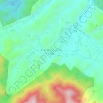
Nombre: Mapa topográfico Kampung Janda Baik, altitud, relieve.
Lugar: Kampung Janda Baik, Bentong, Pahang, 28750, Malaysia (3.30276 101.82868 3.34276 101.86868)
Altitud media: 501 m
Altitud mínima: 351 m
Altitud máxima: 895 m
Before Janda Baik was founded in 1930, the area was primarily inhabited by Orang Asli tribes. The village was founded when some residents moved from Bentong to an area with a higher elevation due to the 1926 floods that affected Bentong and other low elevation areas. The earliest founders for this village are Haji Deris, Haji Kadir, and Haji Yasir, who built a hut and stayed in the area for almost a week before others start to populate the area. The village was originally given the name Kampung Tiga Haji to refer to the three early settlers.
Otros mapas topográficos
Haga clic en un mapa para ver su topografía, su altitud y su relieve.
Kampung Chamang
Kampung Chamang, Bentong, Pahang, 29700, Malaysia
Altitud media: 164 m
Kampung Perting
Kampung Perting, Bentong, Pahang, 29700, Malaysia
Altitud media: 154 m
Bukit Raka
Bukit Raka, Bentong, Pahang, 29700, Malaysia
Altitud media: 251 m
Kampung Benus
Kampung Benus, Bentong, Pahang, 28700, Malaysia
Altitud media: 132 m
Jeriau Waterfall
Jeriau Waterfall, Bentong, Pahang, Malaysia
Altitud media: 1,073 m
Sungai Kelau
Sungai Kelau, Bentong, Pahang, 28600, Malaysia
Altitud media: 72 m