
Mapa topográfico Bayfield Inlet
Mapa interactivo
Haga clic en el mapa para ver la altitud.
Acerca de este mapa
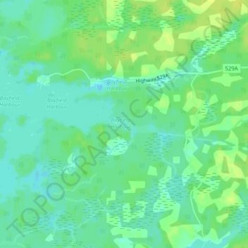
Nombre: Mapa topográfico Bayfield Inlet, altitud, relieve.
Altitud media: 181 m
Altitud mínima: 173 m
Altitud máxima: 191 m
Otros mapas topográficos
Haga clic en un mapa para ver su topografía, su altitud y su relieve.
Keats Island
Canada > Ontario > The Archipelago Township
Keats Island, The Archipelago Township, Parry Sound District, Central Ontario, Ontario, Canada
Altitud media: 194 m
The Archipelago Township
Canada > Ontario > The Archipelago Township
The Archipelago Township, Parry Sound District, Central Ontario, Ontario, P0G 1K0, Canada
Altitud media: 204 m
Naiscoot Lake
Canada > Ontario > The Archipelago Township
Naiscoot Lake, The Archipelago Township, Parry Sound District, Central Ontario, Ontario, Canada
Altitud media: 211 m
Lumsden Island
Canada > Ontario > The Archipelago Township
Lumsden Island, The Archipelago Township, Parry Sound District, Central Ontario, Ontario, Canada
Altitud media: 199 m
Hurontario Island
Canada > Ontario > The Archipelago Township
Hurontario Island, The Archipelago Township, Parry Sound District, Central Ontario, Ontario, Canada
Altitud media: 197 m
Pike Bay
Canada > Ontario > The Archipelago Township
Pike Bay, Nares Inlet Road, The Archipelago Township, Parry Sound District, Central Ontario, Ontario, Canada
Altitud media: 178 m
Brewery Lake
Canada > Ontario > The Archipelago Township
Brewery Lake, Dumont Road, The Archipelago Township, Parry Sound District, Central Ontario, Ontario, Canada
Altitud media: 217 m