
Mapa topográfico Maxatawny
Mapa interactivo
Haga clic en el mapa para ver la altitud.
Acerca de este mapa
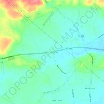
Nombre: Mapa topográfico Maxatawny, altitud, relieve.
Altitud media: 156 m
Altitud mínima: 131 m
Altitud máxima: 226 m
Otros mapas topográficos
Haga clic en un mapa para ver su topografía, su altitud y su relieve.
Bowers
United States > Pennsylvania > Berks County > Maxatawny Township
Bowers, Maxatawny Township, Berks County, Pennsylvania, 19511, United States
Altitud media: 158 m
Eagle Point
United States > Pennsylvania > Berks County > Maxatawny Township
Eagle Point, Maxatawny Township, Berks County, Pennsylvania, 19530, United States
Altitud media: 167 m
Hinterleiter
United States > Pennsylvania > Berks County > Maxatawny Township
Hinterleiter, Maxatawny Township, Berks County, Pennsylvania, 19511, United States
Altitud media: 141 m
Monterey
United States > Pennsylvania > Berks County > Maxatawny Township
Monterey, Maxatawny Township, Berks County, Pennsylvania, 19538, United States
Altitud media: 158 m