
Mapa topográfico Blue Knob
Mapa interactivo
Haga clic en el mapa para ver la altitud.
Acerca de este mapa
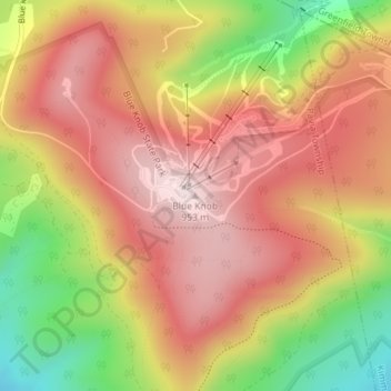
Nombre: Mapa topográfico Blue Knob, altitud, relieve.
Altitud media: 792 m
Altitud mínima: 546 m
Altitud máxima: 957 m
Blue Knob (elevation 3,146 feet (959 m)) is a summit in the eastern United States with a broad dome that is the northernmost 3,000-footer in the Allegheny Mountains. It is the highest point in Bedford County, Pennsylvania.
Otros mapas topográficos
Haga clic en un mapa para ver su topografía, su altitud y su relieve.
Pavia
United States > Pennsylvania > Bedford County > Pavia Township
Pavia, Pavia Township, Bedford County, Pennsylvania, United States
Altitud media: 542 m