
Mapa topográfico Missoula
Mapa interactivo
Haga clic en el mapa para ver la altitud.
Acerca de este mapa
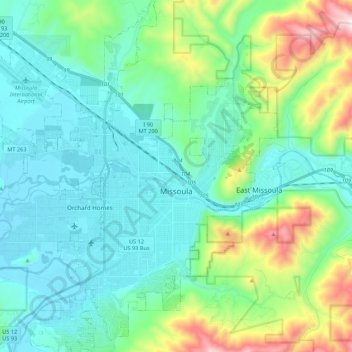
Nombre: Mapa topográfico Missoula, altitud, relieve.
Lugar: Missoula, Missoula County, Montana, United States (46.79154 -114.12729 46.94995 -113.89732)
Altitud media: 1,173 m
Altitud mínima: 943 m
Altitud máxima: 2,021 m
Missoula is located at the western edge of Montana, approximately 45 miles (70 km) from the Idaho border. The city is at an elevation of 3,209 feet (978 m) above sea level, with nearby Mount Sentinel and Mount Jumbo steeply rising to 5,158 feet (1,572 m) and 4,768 feet (1,453 m), respectively. According to the Census Bureau's 2015 figures, the city had a total area of 29.08 square miles (75.3 km2), of which 28.90 square miles (74.9 km2) were land and 0.184 square miles (0.48 km2) were covered by water.
Otros mapas topográficos
Haga clic en un mapa para ver su topografía, su altitud y su relieve.
Bancroft Pond Nature Area
United States > Montana > Missoula County > Missoula
Bancroft Pond Nature Area, Lewis & Clark, Missoula, Missoula County, Montana, United States
Altitud media: 1,005 m
Huston
United States > Montana > Missoula County
Huston, Missoula County, Montana, United States
Altitud media: 2,321 m