
Mapa topográfico Tamacine
Mapa interactivo
Haga clic en el mapa para ver la altitud.
Acerca de este mapa
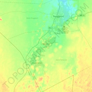
Nombre: Mapa topográfico Tamacine, altitud, relieve.
Lugar: Tamacine, Tamacine District, Touggourt, Algeria (32.94535 5.84629 33.05991 6.24195)
Altitud media: 88 m
Altitud mínima: 58 m
Altitud máxima: 143 m
Tamacine lies at an elevation of 82 metres (269 ft) within the system of oases near Touggourt. These oases feature extensive palm groves and other agriculture. Beyond this is the arid and barren landscape of the Sahara, featuring areas of sand dunes (ergs) and flat rocky plains (regs). Lake Tamacine, a small lake covering 2 hectares (4.9 acres) and 402 metres (440 yd) long, lies along the eastern side of the town, and is notable for its variety of birds and fish.
Otros mapas topográficos
Haga clic en un mapa para ver su topografía, su altitud y su relieve.
Blidet Amor
Algeria > Touggourt > Tamacine District > Blidet Amor
Blidet Amor, Tamacine District, Touggourt, Algeria
Altitud media: 94 m