
Mapa topográfico Addlestone
Haga clic en el mapa para ver la altitud.
Addlestone
Elevations range between 11 metres (36 ft) and 40 metres (130 ft). The maximum is on Row Hill recreation ground, Row Town, Addlestone; a ridge that continues to the northwest of Row Town where it is known as Ongar/Spinney Hill, where Great Grove Farm in its centre also reaches this height; the minimum is by the Thames and along the Woburn Park Stream which is the main distributary of The Bourne the main waterway of the village, a stream rising as the Windle Brook in Windlesham cutting a shallow ravine, flowing past the McLaren Technology Centre and Woodham then passing to the east of the village.
Acerca de este mapa
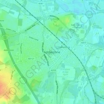
Nombre: Mapa topográfico Addlestone, altitud, relieve.
Altitud media: 18 m
Altitud mínima: 8 m
Altitud máxima: 45 m
Otros mapas topográficos
Haga clic en un mapa para ver su topografía, su altitud y su relieve.
Cooper's Hill Slopes
United Kingdom > England > Surrey > Borough of Runnymede > Englefield Green
Altitud media: 38 m
Chertsey
United Kingdom > England > Surrey > Borough of Runnymede
Samuel Lewis devotes one of his longest entries to the small town in his 1848 topographical guide to England.
Altitud media: 22 m
Egham Wick
United Kingdom > England > Surrey > Borough of Runnymede > Englefield Green
Altitud media: 55 m
Chertsey
United Kingdom > England > Surrey > Borough of Runnymede
Samuel Lewis devotes one of his longest entries to the small town in his 1848 topographical guide to England.
Altitud media: 22 m