
Gracias por apoyar a este sitio ❤️
Haz una donación
Haz una donación
Mapa topográfico Arrah
Haga clic en el mapa para ver la altitud.
Gracias por apoyar a este sitio ❤️
Haz una donación
Haz una donación
Arrah
Arrah is located at the elevation of 192 m from the sea level at the bank of Son river, Ganga River and Gangi River. Arrah lies at the confluence of the Ganga and the Son River, other small rivers that flow in the town are Gangi River, Badki Nadi and Chhotki Nadi.
Gracias por apoyar a este sitio ❤️
Haz una donación
Haz una donación
Acerca de este mapa
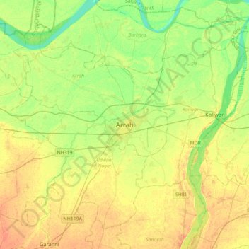
Nombre: Mapa topográfico Arrah, altitud, relieve.
Lugar: Arrah, Bhojpur, Bihar, 802300, India (25.40032 84.50321 25.72032 84.82321)
Altitud media: 59 m
Altitud mínima: 43 m
Altitud máxima: 73 m
Gracias por apoyar a este sitio ❤️
Haz una donación
Haz una donación