
Mapa topográfico Hamburg
Mapa interactivo
Haga clic en el mapa para ver la altitud.
Hamburg
The neighborhoods of Neuenfelde, Cranz, Francop and Finkenwerder are part of the Altes Land (old land) region, the largest contiguous fruit-producing region in Central Europe. Neugraben-Fischbek has Hamburg's highest elevation, the Hasselbrack at 116.2 metres (381 ft) AMSL. Hamburg borders the states of Schleswig-Holstein and Lower Saxony.
Acerca de este mapa
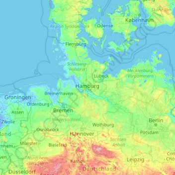
Nombre: Mapa topográfico Hamburg, altitud, relieve.
Lugar: Hamburg, Germany (50.98376 7.44991 56.10376 12.56991)
Altitud media: 56 m
Altitud mínima: -6 m
Altitud máxima: 1,074 m