
Mapa topográfico Madill
Mapa interactivo
Haga clic en el mapa para ver la altitud.
Acerca de este mapa
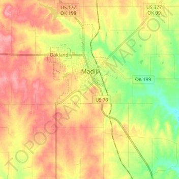
Nombre: Mapa topográfico Madill, altitud, relieve.
Lugar: Madill, Marshall County, Oklahoma, 73446, United States (34.02561 -96.79837 34.13279 -96.72625)
Altitud media: 248 m
Altitud mínima: 198 m
Altitud máxima: 290 m
There is also a small municipal airport (FAA code 1F4) named Madill Municipal Airport, 3 miles (4.8 km) northwest of the city. It has one asphalt runway, 18/36, that is 3,000 feet (910 m) by 60 feet (18 m) at elevation 862 feet (263 m). The airport beacon operates between sunrise and sunset every day. There is no control tower.
Otros mapas topográficos
Haga clic en un mapa para ver su topografía, su altitud y su relieve.
Lake Texoma
United States > Oklahoma > Marshall County
Lake Texoma, Marshall County, Oklahoma, United States
Altitud media: 213 m
Antioch
United States > Oklahoma > Marshall County
Antioch, Marshall County, Oklahoma, United States
Altitud media: 269 m
Kingston
United States > Oklahoma > Marshall County
Kingston, Marshall County, Oklahoma, United States
Altitud media: 239 m
Cumberland
United States > Oklahoma > Marshall County > Cumberland
Cumberland, Marshall County, Oklahoma, United States
Altitud media: 212 m