
Mapa topográfico Val Veny
Mapa interactivo
Haga clic en el mapa para ver la altitud.
Acerca de este mapa
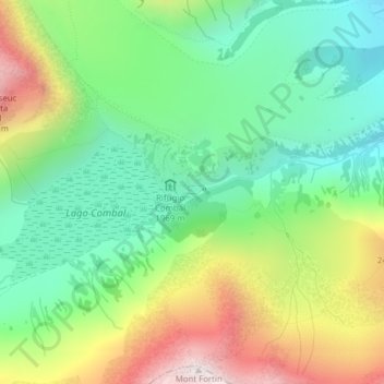
Nombre: Mapa topográfico Val Veny, altitud, relieve.
Lugar: Val Veny, Courmayeur, Valle d'Aosta, Italië (45.76587 6.85992 45.78587 6.87992)
Altitud media: 2,151 m
Altitud mínima: 1,801 m
Altitud máxima: 2,755 m
Otros mapas topográficos
Haga clic en un mapa para ver su topografía, su altitud y su relieve.
Lechey Desot
Italië > Valle d'Aosta > Courmayeur
Lechey Desot, Courmayeur, Valle d'Aosta, 11013, Italië
Altitud media: 1,814 m
Peindein
Italië > Valle d'Aosta > Courmayeur > Peindein
Peindein, Courmayeur, Valle d'Aosta, 11013, Italië
Altitud media: 1,741 m
Picco Luigi Amedeo
Italië > Valle d'Aosta > Courmayeur
Picco Luigi Amedeo, Courmayeur, Valle d'Aosta, Italië
Altitud media: 3,790 m