
Haz una donación
Mapa topográfico East Lindsey
Haga clic en el mapa para ver la altitud.
Haz una donación
Acerca de este mapa
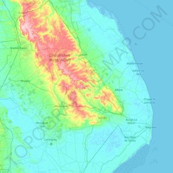
Nombre: Mapa topográfico East Lindsey, altitud, relieve.
Altitud media: 24 m
Altitud mínima: -1 m
Altitud máxima: 169 m
Haz una donación
Otros mapas topográficos
Haga clic en un mapa para ver su topografía, su altitud y su relieve.
Haz una donación
Haz una donación
Limber Hill
United Kingdom > England > Lincolnshire > West Lindsey > Great Limber CP
Altitud media: 45 m
Haz una donación
Ashby by Partney
United Kingdom > England > Lincolnshire > East Lindsey > Halton Holegate
Altitud media: 20 m
Haz una donación
Haz una donación
Haz una donación
Haz una donación
Haz una donación
Haz una donación
Haz una donación
Haz una donación
Caen Hill
United Kingdom > England > Lincolnshire > West Lindsey > Great Limber CP
Altitud media: 83 m
Haz una donación
Holbeach Clough
United Kingdom > England > Lincolnshire > South Holland > Holbeach CP > Saracen's Head
Altitud media: 4 m
Haz una donación
Moor Barn
United Kingdom > England > Lincolnshire > South Kesteven > Hough-on-the-Hill
Altitud media: 31 m
Haz una donación
Haz una donación
Haz una donación
Haz una donación
Haz una donación
Haz una donación
Haz una donación
Haz una donación
Shepeau Stow
United Kingdom > England > Lincolnshire > South Holland > Whaplode Drove
Altitud media: 2 m
Haz una donación
Haz una donación
Low Fulney Estate
United Kingdom > England > Lincolnshire > South Holland > Spalding
Altitud media: 4 m
Haz una donación
Sempringham
United Kingdom > England > Lincolnshire > South Kesteven > Pointon
Sempringham consists of a church and a holy well, with other houses east from the church scattered along the B1177 between Pointon and Billingborough. The church stands at an altitude of about 52 feet (16 m), on land rising out of flat fenland. Pointon is the chief township of the civil parish, which includes…
Altitud media: 16 m
Haz una donación