
Gracias por apoyar a este sitio ❤️
Haz una donación
Haz una donación
Mapa topográfico Barton
Haga clic en el mapa para ver la altitud.
Gracias por apoyar a este sitio ❤️
Haz una donación
Haz una donación
Acerca de este mapa
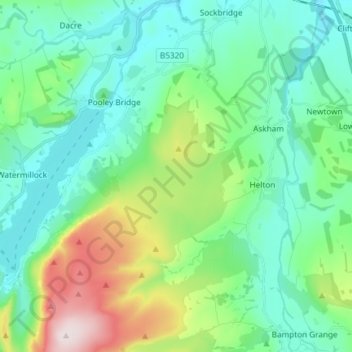
Nombre: Mapa topográfico Barton, altitud, relieve.
Lugar: Barton, Eden District, Cumbria, England, United Kingdom (54.55135 -2.85874 54.63711 -2.77365)
Altitud media: 259 m
Altitud mínima: 130 m
Altitud máxima: 671 m
Gracias por apoyar a este sitio ❤️
Haz una donación
Haz una donación
Otros mapas topográficos
Haga clic en un mapa para ver su topografía, su altitud y su relieve.
Gracias por apoyar a este sitio ❤️
Haz una donación
Haz una donación
Gracias por apoyar a este sitio ❤️
Haz una donación
Haz una donación
Dufton Pike
United Kingdom > England > Cumbria > Eden District
Dufton Pike is a hill in the northern Pennines, in Cumbria, England. It is classed as a Marilyn (a hill with topographic prominence of at least 150m). It rises above the village of Dufton.
Altitud media: 313 m