
Mapa topográfico Dallas
Mapa interactivo
Haga clic en el mapa para ver la altitud.
Acerca de este mapa
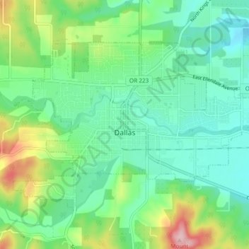
Nombre: Mapa topográfico Dallas, altitud, relieve.
Lugar: Dallas, Polk County, Oregon, 97338, United States (44.90314 -123.34915 44.93801 -123.27495)
Altitud media: 119 m
Altitud mínima: 67 m
Altitud máxima: 251 m
Dallas is along Rickreall Creek, about 15 miles (24 km) west of Salem, at an elevation of 325 feet (99 m) above sea level. It is part of the Salem Metropolitan Statistical Area.
Otros mapas topográficos
Haga clic en un mapa para ver su topografía, su altitud y su relieve.
Willamette River
United States > Oregon > Polk County
Willamette River, Polk County, Oregon, United States
Altitud media: 72 m
Monmouth
United States > Oregon > Polk County
Monmouth, Polk County, Oregon, United States
Altitud media: 58 m
Buena Vista
United States > Oregon > Polk County
Buena Vista, Polk County, Oregon, United States
Altitud media: 67 m
Aaron Mercer Reservoir
United States > Oregon > Polk County
Aaron Mercer Reservoir, Polk County, Oregon, United States
Altitud media: 367 m
Independence
United States > Oregon > Polk County
Independence, Polk County, Oregon, 97351, United States
Altitud media: 50 m
Grand Ronde
United States > Oregon > Polk County > Grand Ronde
Grand Ronde, Polk County, Oregon, United States
Altitud media: 132 m