
Mapa topográfico Aberdeen
Mapa interactivo
Haga clic en el mapa para ver la altitud.
Acerca de este mapa
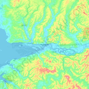
Nombre: Mapa topográfico Aberdeen, altitud, relieve.
Altitud media: 66 m
Altitud mínima: -5 m
Altitud máxima: 286 m
Aberdeen is at the eastern end of Grays Harbor, near the mouth of the Chehalis River and southwest of the Olympic Mountains. Grays Harbor is notable as the northernmost ria on North America's Pacific Coast because it has remained free of glaciers throughout the Quaternary due to unfavorable topography and warm temperatures. It is thought that, during glacial periods of the Quaternary, the Chehalis River was a major refugium for aquatic species, as was the west coast from the Olympic Peninsula southward for plants that later formed the northern part of the Pacific temperate rainforest in formerly glaciated areas.
Otros mapas topográficos
Haga clic en un mapa para ver su topografía, su altitud y su relieve.
North Aberdeen
United States > Washington > Grays Harbor County > Aberdeen > North Aberdeen
North Aberdeen, Aberdeen, Grays Harbor County, Washington, 98537-0525, United States
Altitud media: 37 m