
Mapa topográfico Renukut
Mapa interactivo
Haga clic en el mapa para ver la altitud.
Acerca de este mapa
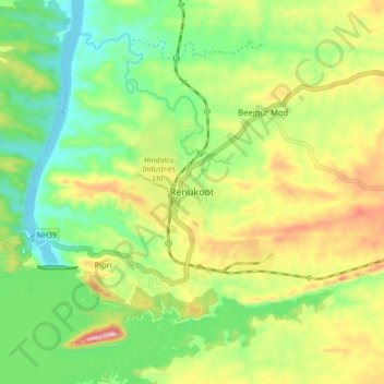
Nombre: Mapa topográfico Renukut, altitud, relieve.
Altitud media: 285 m
Altitud mínima: 194 m
Altitud máxima: 423 m
Renukoot is located at 24°12′N 83°02′E / 24.2°N 83.03°E / 24.2; 83.03. It has an average elevation of 283 metres (931 feet). Renukoot lies in the southeast-most part of Uttar Pradesh and sits next to Shakti Nagar, Anpara, ((Dalla)) and Obra. Renukoot is in Sonebhadra district which is the only district in India which borders four states, namely Madhya Pradesh, Chhattisgarh, Jharkhand, and Bihar.