
Mapa topográfico West Bath
Mapa interactivo
Haga clic en el mapa para ver la altitud.
Acerca de este mapa
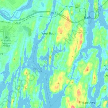
Nombre: Mapa topográfico West Bath, altitud, relieve.
Lugar: West Bath, Sagadahoc County, Maine, United States (43.81448 -69.89601 43.93159 -69.82855)
Altitud media: 15 m
Altitud mínima: -3 m
Altitud máxima: 80 m
Otros mapas topográficos
Haga clic en un mapa para ver su topografía, su altitud y su relieve.
Georgetown Island
United States > Maine > Sagadahoc County > Georgetown
Georgetown Island, Georgetown, Sagadahoc County, Maine, 04548, United States
Altitud media: 15 m
Woolwich
United States > Maine > Sagadahoc County
Woolwich, Sagadahoc County, Maine, 04579, United States
Altitud media: 21 m
Arrowsic
United States > Maine > Sagadahoc County
Arrowsic, Sagadahoc County, Maine, United States
Altitud media: 18 m
Richmond
United States > Maine > Sagadahoc County
Richmond, Sagadahoc County, Maine, 04357, United States
Altitud media: 46 m
Drummore Bay
United States > Maine > Sagadahoc County > Phippsburg
Drummore Bay, Phippsburg, Sagadahoc County, Maine, 04562, United States
Altitud media: 17 m
Bowdoinham
United States > Maine > Sagadahoc County
Bowdoinham, Sagadahoc County, Maine, 04008, United States
Altitud media: 44 m
Topsham
United States > Maine > Sagadahoc County
Topsham, Sagadahoc County, Maine, 04086, United States
Altitud media: 39 m
MacMahan Island
United States > Maine > Sagadahoc County > Georgetown
MacMahan Island, Georgetown, Sagadahoc County, Maine, United States
Altitud media: 8 m
Phippsburg
United States > Maine > Sagadahoc County
Phippsburg, Sagadahoc County, Maine, United States
Altitud media: 7 m
Georgetown
United States > Maine > Sagadahoc County
Georgetown, Sagadahoc County, Maine, 04548, United States
Altitud media: 8 m
Bath
United States > Maine > Sagadahoc County
Bath, Sagadahoc County, Maine, 04530, United States
Altitud media: 16 m