
Mapa topográfico Rindge
Mapa interactivo
Haga clic en el mapa para ver la altitud.
Rindge
According to the United States Census Bureau, the town has a total area of 39.8 square miles (103.1 km2), of which 37.1 square miles (96.1 km2) are land and 2.7 square miles (7.0 km2) are water, comprising 6.76% of the town. Rindge is located in a hilly upland lake region. Hubbard Pond is in the northeast, Contoocook Lake on the northern boundary, Pearly Lake is in the northwest, and Lake Monomonac is on the southern boundary. The town is located on a regional watershed divide and is the headwaters for two river systems. The Contoocook River flows north to the Merrimack River, thence to the Gulf of Maine, and the North Branch of the Millers River flows southwest to the Connecticut River, thence to Long Island Sound. Rindge's highest point is on its eastern border, on the lower slopes of Pratt Mountain, where the elevation reaches 1,505 feet (459 m) above sea level.
Acerca de este mapa
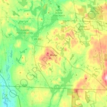
Nombre: Mapa topográfico Rindge, altitud, relieve.
Lugar: Rindge, Cheshire County, New Hampshire, United States (42.71216 -72.09126 42.79331 -71.92886)
Altitud media: 343 m
Altitud mínima: 256 m
Altitud máxima: 481 m
Otros mapas topográficos
Haga clic en un mapa para ver su topografía, su altitud y su relieve.
Mount Monadnock
United States > New Hampshire > Cheshire County > Jaffrey
From the base to the summit, floral species diminish with increasingly shallow soil levels. The summit is home to many different specialized sub-alpine species which can retain moisture for long periods of time. Alpine and sub-alpine species include mountain ash, cotton grass, sheep laurel, mountain sandwort,…
Altitud media: 687 m