
Mapa topográfico Accokeek
Mapa interactivo
Haga clic en el mapa para ver la altitud.
Acerca de este mapa
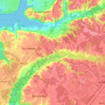
Nombre: Mapa topográfico Accokeek, altitud, relieve.
Altitud media: 46 m
Altitud mínima: -3 m
Altitud máxima: 74 m
According to the United States Census Bureau, the place has a total area of 28.803 square miles (74.60 km2), of which 27.436 square miles (71.06 km2) is land and 1.367 square miles (3.54 km2) is water. Accokeek has an average elevation of 194 feet (59 m).
Otros mapas topográficos
Haga clic en un mapa para ver su topografía, su altitud y su relieve.
White Hall
United States > Maryland > Prince George's County > Accokeek
White Hall, Accokeek, Prince George's County, Maryland, 20607, United States
Altitud media: 36 m