
Mapa topográfico Ticehurst
Mapa interactivo
Haga clic en el mapa para ver la altitud.
Acerca de este mapa
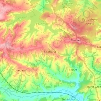
Nombre: Mapa topográfico Ticehurst, altitud, relieve.
Lugar: Ticehurst, Rother, East Sussex, England, United Kingdom (51.00962 0.34657 51.08365 0.47187)
Altitud media: 81 m
Altitud mínima: 13 m
Altitud máxima: 154 m
Otros mapas topográficos
Haga clic en un mapa para ver su topografía, su altitud y su relieve.
Bexhill-on-Sea
United Kingdom > England > East Sussex > Rother
Bexhill-on-Sea, Rother, East Sussex, England, TN39 3PE, United Kingdom
Altitud media: 13 m
Battle
United Kingdom > England > East Sussex > Rother > Battle
Battle, Rother, East Sussex, South East England, England, United Kingdom
Altitud media: 66 m
Burwash
United Kingdom > England > East Sussex > Rother
Burwash, Rother, East Sussex, England, TN19 7EP, United Kingdom
Altitud media: 56 m