
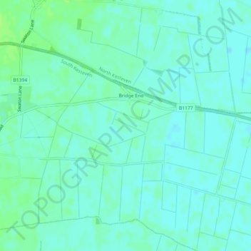
Mapa topográfico Bridge Hills
Mapa interactivo
Haga clic en el mapa para ver la altitud.
Acerca de este mapa
Nombre: Mapa topográfico Bridge Hills, altitud, relieve.
Altitud media: 4 m
Altitud mínima: 0 m
Altitud máxima: 10 m
Otros mapas topográficos
Haga clic en un mapa para ver su topografía, su altitud y su relieve.
Grantham
United Kingdom > England > Lincolnshire > South Kesteven
Grantham, South Kesteven, Lincolnshire, England, NG31 6LJ, United Kingdom
Altitud media: 87 m
Thurlby
United Kingdom > England > Lincolnshire > South Kesteven > Thurlby
Thurlby, South Kesteven, Lincolnshire, East Midlands, England, PE10 0QD, United Kingdom
Altitud media: 20 m
Stamford
United Kingdom > England > Lincolnshire > South Kesteven
Stamford, South Kesteven, Lincolnshire, England, PE9 2AJ, United Kingdom
Altitud media: 52 m
Bourne
United Kingdom > England > Lincolnshire > South Kesteven
Bourne, South Kesteven, Lincolnshire, England, PE10 9ED, United Kingdom
Altitud media: 21 m
Barkston
United Kingdom > England > Lincolnshire > South Kesteven
Barkston, South Kesteven, Lincolnshire, England, NG32 2NH, United Kingdom
Altitud media: 62 m
Grantham
United Kingdom > England > Lincolnshire > South Kesteven
Grantham, South Kesteven, Lincolnshire, England, United Kingdom
Altitud media: 85 m