
Mapa topográfico Dykes of Gray
Mapa interactivo
Haga clic en el mapa para ver la altitud.
Acerca de este mapa
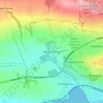
Nombre: Mapa topográfico Dykes of Gray, altitud, relieve.
Lugar: Dykes of Gray, Dundee City, Scotland, DD2 5GS, United Kingdom (56.45181 -3.09055 56.49181 -3.05055)
Altitud media: 57 m
Altitud mínima: 0 m
Altitud máxima: 164 m
Otros mapas topográficos
Haga clic en un mapa para ver su topografía, su altitud y su relieve.
Dundee
United Kingdom > Scotland > Dundee City
Dundee, Dundee City, Scotland, DD1 1SG, United Kingdom
Altitud media: 82 m
Broughty Castle
United Kingdom > Scotland > Dundee City > Dundee
Broughty Castle, Castle Approach, Broughty Ferry, Dundee, Dundee City, Scotland, DD5 2TF, United Kingdom
Altitud media: 10 m
Camperdown Country Park
United Kingdom > Scotland > Dundee City > Dundee
Camperdown Country Park, Dundee, Dundee City, Scotland, DD2 4TF, United Kingdom
Altitud media: 120 m
Drumgeith Park
United Kingdom > Scotland > Dundee City > Dundee
Drumgeith Park, Whitfield, Dundee, Dundee City, Scotland, United Kingdom
Altitud media: 54 m
Claypotts Castle
United Kingdom > Scotland > Dundee City > Dundee
Claypotts Castle, Claypotts Castle Gardens, Broughty Ferry, Dundee, Dundee City, Scotland, DD5 3JY, United Kingdom
Altitud media: 28 m