
Mapa topográfico County Down
Mapa interactivo
Haga clic en el mapa para ver la altitud.
Acerca de este mapa
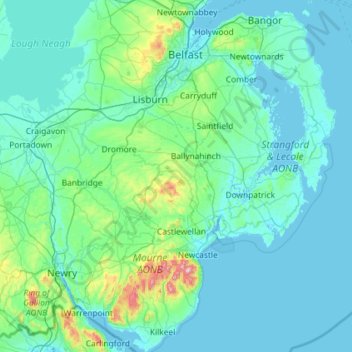
Nombre: Mapa topográfico County Down, altitud, relieve.
Lugar: County Down, Northern Ireland, United Kingdom (54.02289 -6.40037 54.69924 -5.42682)
Altitud media: 65 m
Altitud mínima: -3 m
Altitud máxima: 839 m
Otros mapas topográficos
Haga clic en un mapa para ver su topografía, su altitud y su relieve.
Newry
United Kingdom > Northern Ireland > County Down
Newry, County Down, Northern Ireland, United Kingdom
Altitud media: 73 m
Dundonald
United Kingdom > Northern Ireland > County Down
Dundonald, County Down, Ulster, Northern Ireland, BT16 1RH, United Kingdom
Altitud media: 80 m
Killough
United Kingdom > Northern Ireland > County Down
Killough, County Down, Ulster, Northern Ireland, BT30 7QQ, United Kingdom
Altitud media: 7 m
Ballynahinch
United Kingdom > Northern Ireland > County Down > Ballynahinch
Ballynahinch, County Down, Ulster, Northern Ireland, BT24 8DN, United Kingdom
Altitud media: 99 m
Lawrencetown
United Kingdom > Northern Ireland > County Down
Lawrencetown, County Down, Northern Ireland, BT63 6DU, United Kingdom
Altitud media: 72 m
Saintfield
United Kingdom > Northern Ireland > County Down
Saintfield, County Down, Ulster, Northern Ireland, BT24 7AA, United Kingdom
Altitud media: 87 m