
Gracias por apoyar a este sitio ❤️
Haz una donación
Haz una donación
Mapa topográfico Albstadt
Haga clic en el mapa para ver la altitud.
Gracias por apoyar a este sitio ❤️
Haz una donación
Haz una donación
Albstadt
Albstadt is spread across a variety of hills and valleys, its elevation ranges between 614 m (2,014 ft) above sea level and 966 m (3,169 ft). One valley is the river Schmiecha, a left-hand tributary of the Danube, a second valley is the river of upper Eyach, a tributary of the Neckar.
Gracias por apoyar a este sitio ❤️
Haz una donación
Haz una donación
Acerca de este mapa
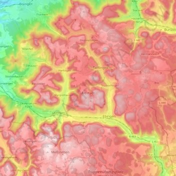
Nombre: Mapa topográfico Albstadt, altitud, relieve.
Altitud media: 814 m
Altitud mínima: 511 m
Altitud máxima: 989 m
Gracias por apoyar a este sitio ❤️
Haz una donación
Haz una donación
Otros mapas topográficos
Haga clic en un mapa para ver su topografía, su altitud y su relieve.