
Mapa topográfico Clitheroe
Haga clic en el mapa para ver la altitud.
Acerca de este mapa
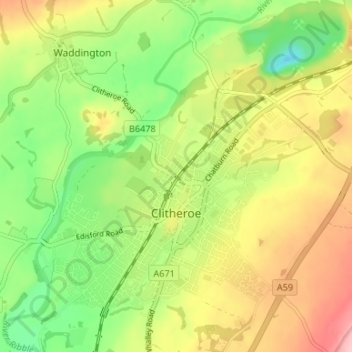
Nombre: Mapa topográfico Clitheroe, altitud, relieve.
Lugar: Clitheroe, Ribble Valley, Lancashire, England, United Kingdom (53.85666 -2.42473 53.89501 -2.35846)
Altitud media: 84 m
Altitud mínima: 13 m
Altitud máxima: 167 m
Otros mapas topográficos
Haga clic en un mapa para ver su topografía, su altitud y su relieve.
Billington and Langho
United Kingdom > England > Lancashire > Ribble Valley > Brockhall Village
Altitud media: 58 m
Old Langho
United Kingdom > England > Lancashire > Ribble Valley > Brockhall Village
Altitud media: 74 m
Brungerley Park
United Kingdom > England > Lancashire > Ribble Valley > Clitheroe > Waddington
Altitud media: 77 m
Mellor Brook
United Kingdom > England > Lancashire > Ribble Valley > Mellor Brook
Altitud media: 106 m