
Gracias por apoyar a este sitio ❤️
Haz una donación
Haz una donación
Mapa topográfico Burladingen
Haga clic en el mapa para ver la altitud.
Gracias por apoyar a este sitio ❤️
Haz una donación
Haz una donación
Burladingen
The township (Stadt) of Burladingen is located in the Swabian Jura, specifically where the Middle Kuppenalb [de] transitions into the western Jura. Elevation above sea level in the municipal area varies from a low of 611 meters (2,005 ft) Normalnull (NN) to a high of 933 meters (3,061 ft).
Gracias por apoyar a este sitio ❤️
Haz una donación
Haz una donación
Acerca de este mapa
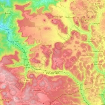
Nombre: Mapa topográfico Burladingen, altitud, relieve.
Lugar: Burladingen, Zollernalbkreis, Baden-Württemberg, 72393, Germany (48.25209 9.02464 48.37667 9.22166)
Altitud media: 784 m
Altitud mínima: 531 m
Altitud máxima: 970 m
Gracias por apoyar a este sitio ❤️
Haz una donación
Haz una donación
Otros mapas topográficos
Haga clic en un mapa para ver su topografía, su altitud y su relieve.