
Mapa topográfico Eddleston
Mapa interactivo
Haga clic en el mapa para ver la altitud.
Acerca de este mapa
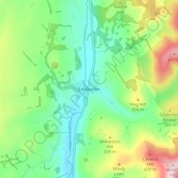
Nombre: Mapa topográfico Eddleston, altitud, relieve.
Altitud media: 282 m
Altitud mínima: 182 m
Altitud máxima: 481 m
Otros mapas topográficos
Haga clic en un mapa para ver su topografía, su altitud y su relieve.
Viewfield
United Kingdom > Scotland > Scottish Borders
Viewfield, Scottish Borders, Scotland, TD10 6UW, United Kingdom
Altitud media: 136 m
Hawick
United Kingdom > Scotland > Scottish Borders
Hawick, Scottish Borders, Scotland, TD9 9EG, United Kingdom
Altitud media: 199 m
Willie's Law
United Kingdom > Scotland > Scottish Borders
Willie's Law, Scottish Borders, Scotland, United Kingdom
Altitud media: 472 m
Galashiels
United Kingdom > Scotland > Scottish Borders
Galashiels, Scottish Borders, Scotland, United Kingdom
Altitud media: 221 m
Cavers
United Kingdom > Scotland > Scottish Borders > Cavers
Cavers, Scottish Borders, Scotland, TD9 8LJ, United Kingdom
Altitud media: 157 m