
Mapa topográfico Lichtenfels
Mapa interactivo
Haga clic en el mapa para ver la altitud.
Acerca de este mapa
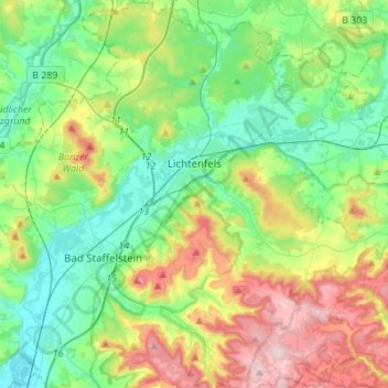
Nombre: Mapa topográfico Lichtenfels, altitud, relieve.
Lugar: Lichtenfels, Landkreis Lichtenfels, Bayern, 96215, Deutschland (50.04347 10.97516 50.21959 11.18991)
Altitud media: 348 m
Altitud mínima: 243 m
Altitud máxima: 575 m
Bohnberg | Buch am Forst | Burgberg | Degendorf | Eichig | Friesenhof | Gnellenroth | Hammer | Heinach | Isling | Karolinenhöhe | Klosterlangheim | Kösten | Köttel | Krappenroth | Lahm | Mistelfeld | Mönchkröttendorf | Nassanger | Oberlangheim | Oberwallenstadt | Reundorf | Roth | Rothmannsthal | Schney | Schönsreuth | Seehof | Seubelsdorf | Stetten | Stöcken | Tiefenroth | Trieb | Unterwallenstadt | Weingarten
Otros mapas topográficos
Haga clic en un mapa para ver su topografía, su altitud y su relieve.
Schwabthal
Deutschland > Bayern > Landkreis Lichtenfels > Bad Staffelstein
Schwabthal, Bad Staffelstein, Landkreis Lichtenfels, Bayern, Deutschland
Altitud media: 432 m
Döringstadt
Deutschland > Bayern > Landkreis Lichtenfels
Döringstadt, Ebensfeld, Landkreis Lichtenfels, Bayern, 96250, Deutschland
Altitud media: 299 m
Schwürbitz
Deutschland > Bayern > Landkreis Lichtenfels
Schwürbitz, Michelau i.OFr., Landkreis Lichtenfels, Bayern, 96275, Deutschland
Altitud media: 292 m