
Haz una donación
Mapa topográfico Clark
Haga clic en el mapa para ver la altitud.
Haz una donación
Clark
The development is not a flood-prone area with its minimum elevation being at 54 metres (177 ft) above sea level and its planned central park also serves as a flood catchment basin. The Sierra Madre mountain range is located on the development's east while the Zambales mountain range is located on the west, with both geographical features providing New Clark City a natural protection from typhoons. The maximum elevation of New Clark City is at around 800 metres (2,600 ft).
Haz una donación
Acerca de este mapa
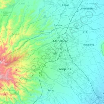
Nombre: Mapa topográfico Clark, altitud, relieve.
Lugar: Clark, Mabalacat, Pampanga, Central Luzon, 2023, Philippines (15.03094 120.38700 15.35094 120.70700)
Altitud media: 190 m
Altitud mínima: 3 m
Altitud máxima: 1,231 m
Haz una donación
Otros mapas topográficos
Haga clic en un mapa para ver su topografía, su altitud y su relieve.
Guagua
The climate and topographical features of the vast land of Guagua make it ideal for the growing of fruit trees and vegetables. Among the fruit trees most fitting to be planted are mangoes, guavas, santol, star apples, and bananas. For vegetables, sitao, upo, ampalaya, gabi and cucumber are the most commonly…
Altitud media: 9 m
Haz una donación