Geolocalizar

Mapa topográfico Ohrdruf

Mapa interactivo

Haga clic en el mapa para ver la altitud.

Acerca de este mapa

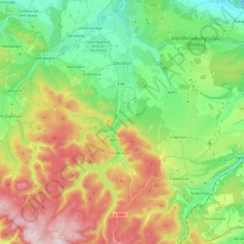
Nombre: Mapa topográfico Ohrdruf, altitud, relieve.

Lugar: Ohrdruf, Landkreis Gotha, Thuringia, 99885, Germany (50.71568 10.63015 50.86566 10.85992)

Altitud media: 518 m

Altitud mínima: 288 m

Altitud máxima: 890 m

Otros mapas topográficos

Haga clic en un mapa para ver su topografía, su altitud y su relieve.

Schwabhausen

Germany > Thuringia > Landkreis Gotha

Schwabhausen, Drei Gleichen, Landkreis Gotha, Thuringia, Germany

Altitud media: 352 m

Burgtonna

Germany > Thuringia > Landkreis Gotha

Burgtonna, Tonna, Fahner Höhe, Landkreis Gotha, Thuringia, 99958, Germany

Altitud media: 234 m

Tonna

Germany > Thuringia > Landkreis Gotha

Tonna, Fahner Höhe, Landkreis Gotha, Thuringia, 99958, Germany

Altitud media: 228 m

Gotha

Germany > Thuringia > Landkreis Gotha

Gotha, Landkreis Gotha, Thuringia, 99867, Germany

Altitud media: 320 m