
Mapa topográfico Georgetown
Mapa interactivo
Haga clic en el mapa para ver la altitud.
Acerca de este mapa
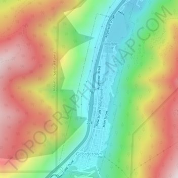
Nombre: Mapa topográfico Georgetown, altitud, relieve.
Altitud media: 2,974 m
Altitud mínima: 2,557 m
Altitud máxima: 3,502 m
The town sits at an elevation of 8,530 feet (2,600 m) above sea level, nestled in the mountains near the upper end of the valley of Clear Creek in the mountains west of Denver along Interstate 70. Although population was only about 1,000 at the 2010 census, the town was a historic center of the mining industry in Colorado during the late 19th century, earning the nickname the "Silver Queen of Colorado". It has evolved into a lively historical summer tourist center today with many preserved structures from the heyday of the Colorado Silver Boom. The town stretches roughly north–south along Clear Creek, hemmed in by the mountains, with the historic downtown located at the southern (upper) end and modern development located at the northern (lower) end of town. Georgetown is now a part of the Denver–Aurora–Lakewood, CO Metropolitan Statistical Area and the Front Range Urban Corridor.
Otros mapas topográficos
Haga clic en un mapa para ver su topografía, su altitud y su relieve.
Idaho Springs
United States > Colorado > Clear Creek County
Idaho Springs, Clear Creek County, Colorado, 80452, United States
Altitud media: 2,663 m
Bakerville
United States > Colorado > Clear Creek County
Bakerville, Clear Creek County, Colorado, 80476, United States
Altitud media: 3,332 m
Saint Marys
United States > Colorado > Clear Creek County
Saint Marys, Clear Creek County, Colorado, United States
Altitud media: 3,202 m
Downieville
United States > Colorado > Clear Creek County
Downieville, Clear Creek County, Colorado, 80436, United States
Altitud media: 2,713 m
Dumont
United States > Colorado > Clear Creek County
Dumont, Clear Creek County, Colorado, 80436, United States
Altitud media: 2,672 m
Floyd Hill Open Space
United States > Colorado > Clear Creek County
Floyd Hill Open Space, Clear Creek County, Colorado, United States
Altitud media: 2,445 m
Empire
United States > Colorado > Clear Creek County
Empire, Clear Creek County, Colorado, 80438, United States
Altitud media: 2,754 m
Argo Mill
United States > Colorado > Clear Creek County > Idaho Springs
Argo Mill, Idaho Springs, Clear Creek County, Colorado, 80452, United States
Altitud media: 2,507 m
Mount Evans
United States > Colorado > Clear Creek County
Mount Evans, Clear Creek County, Colorado, United States
Altitud media: 4,006 m
Goliath Peak
United States > Colorado > Clear Creek County
Goliath Peak, Clear Creek County, Colorado, United States
Altitud media: 3,455 m
St. Mary's
United States > Colorado > Clear Creek County
St. Mary's, Clear Creek County, Colorado, United States
Altitud media: 3,281 m
Breckinridge Peak
United States > Colorado > Clear Creek County
Breckinridge Peak, Clear Creek County, Colorado, United States
Altitud media: 3,637 m
Woods Mountain
United States > Colorado > Clear Creek County
Woods Mountain, Clear Creek County, Colorado, United States
Altitud media: 3,669 m
Silver Plume
United States > Colorado > Clear Creek County
Silver Plume, Clear Creek County, Colorado, United States
Altitud media: 3,106 m