
Mapa topográfico Mount Barker
Mapa interactivo
Haga clic en el mapa para ver la altitud.
Acerca de este mapa
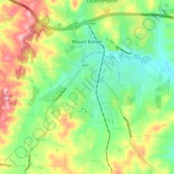
Nombre: Mapa topográfico Mount Barker, altitud, relieve.
Altitud media: 368 m
Altitud mínima: 302 m
Altitud máxima: 467 m
Mount Barker is located on the plains surrounding the Mount Barker Summit, about 2 km west of the mountain itself, at 35°04′S 138°51′E / 35.067°S 138.850°E / -35.067; 138.850. Mount Barker is south east of Mount Lofty and Adelaide. It is to the north of The Coorong, and the west of Murray Bridge. Mount Barker is at an elevation of 360 m.