
Haz una donación
Mapa topográfico Weets Hill
Haga clic en el mapa para ver la altitud.
Haz una donación
Acerca de este mapa
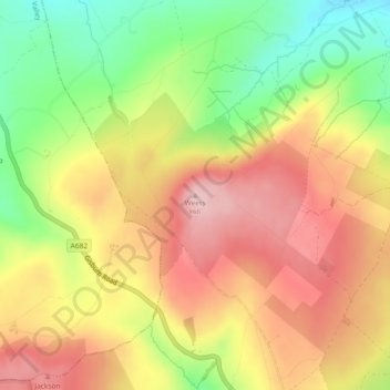
Nombre: Mapa topográfico Weets Hill, altitud, relieve.
Altitud media: 300 m
Altitud mínima: 187 m
Altitud máxima: 396 m
Haz una donación
Otros mapas topográficos
Haga clic en un mapa para ver su topografía, su altitud y su relieve.
Laneshaw Bridge
United Kingdom > England > Lancashire > Borough of Pendle > Laneshaw Bridge
Altitud media: 269 m
Barnoldswick
United Kingdom > England > Lancashire > Borough of Pendle > Salterforth
Altitud media: 175 m
Colne
United Kingdom > England > Lancashire > Borough of Pendle
Pendle Leisure Trust runs the Pendle Leisure Centre next to the railway station. The facility has two swimming pools, a fitness centre and gymnasium, sauna and sports hall. In summer 2013, the outdoor all-weather pitch was replaced by Urban Altitude. This outdoor aerial assault course is the first of its kind…
Altitud media: 197 m
Colne Water
United Kingdom > England > Lancashire > Borough of Pendle > Laneshaw Bridge
Altitud media: 202 m
Haz una donación
Barnoldswick
United Kingdom > England > Lancashire > Borough of Pendle > Salterforth
Altitud media: 175 m
Haz una donación
Colne
United Kingdom > England > Lancashire > Borough of Pendle
Pendle Leisure Trust runs the Pendle Leisure Centre next to the railway station. The facility has two swimming pools, a fitness centre and gymnasium, sauna and sports hall. In summer 2013, the outdoor all-weather pitch was replaced by Urban Altitude. This outdoor aerial assault course is the first of its kind…
Altitud media: 197 m
Barrowford
United Kingdom > England > Lancashire > Borough of Pendle > Barrowford
Altitud media: 161 m